Western Region of Bhutan


- Bhutan Visitor Info
- Western Region Bhutan -
- Central Region Bhutan -
- Eastern Region Bhutan -
- Festivals of Bhutan -
- National symbols -
- History of Bhutan -
- Culture of Bhutan -
- Religion of Bhutan -
- People of Bhutan -
- Bhutan Visa & Customs -
- Bhutan Accommodation -
- Bhutan Transportation -
- Climate of Bhutan -
- Currency of Bhutan -
- Paro Festival Bhutan -
- Trekking in Bhutan -
Bhutan Mystic Bliss >> WESTERN BHUTAN
WESTERN BHUTAN
For further Details Contact Us
Western Bhutan comprises of the most beautiful valley in the world. Here nature and man consulted to create their dearest image. Mt. Chomoihari 7320m reigns in white glory at the northern end of the valley and its glacial water plunge through deep gorges to form the Pa-Chu (Paro River).
Paro is the name of a district (dzongkhag), valley, river and town in the Kingdom of Bhutan, located at 27°30?N 89°20?E. It is one of the most historic valleys in Bhutan. Both trade goods and invading Tibetans came over the pass at the head of the valley, giving Paro the closest cultural connection with Tibet of any Bhutanese district. Important cultural sites include: 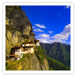
Taktshang, or Tiger's Nest, the most famous monastery in Bhutan.
Kyichu Lhakhang, which along with Jambay Lhakhang in central Bhutan is the oldest temple in Bhutan, dating to the 7th century.
Drukgyel Dzong, at the upper end of the valley, built to protect against invading Tibetans, but in ruins since a fire in the 1950s.
Paro is one of the most fertile valleys in the kingdom producing a bulk of the famous red rice on its terraced fields, home to some of Bhutan's oldest temples & monasteries. The beauty of Paro valley is embellished by cluster of quaint farmhouses. Bhutanese houses are very colorful and traditionally built without the use of a single nail. The house looks very big from outside but is quite simple inside. It's normally three storeys. The ground floor is always used for cattle while the attic is used to store hay. The families live in the middle floor. The best room is always kept for the family chapel. A visit to a farmhouse is very interesting and offers a good glimpse into the lifestyle of a farmer.
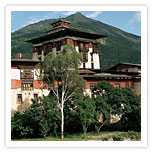
 Paro Town, the single market town in the dzonghag which is booming (by Bhutanese standards) due to an influx of tourist dollars. Rinpung Dzong, also known as Paro Dzong, the massive fortress/monastery is also the administrative center of the dzonkhag. Scenes from the movie Little Buddha were filmed in and around this dzong.
The National Museum of Bhutan, where visitors can learn about the culture of Bhutan is located here. Paro contains the only active international airport in Bhutan, the Paro Airport. A beautiful small green-roofed facility in a valley, served only by Druk Air (Bhutan's National Airline) from India and other countries in Southeast Asia
Paro is bordered by Haa dzongkhag to the west, Tibet to the north, Thimphu to the east, and Chukha dzongkhag to the south.
Paro comprises of ten gewogs or counties:
Doga
Dopshari
Doteng
Hungrel
Lamgong
Lungnyi
Naja
Shapa
Tsento
Waangchang
 THIMPHU (2.300m) the modern capital of Bhutan lies at an elevation of 2300m in a valley traversed by the Wang Chu (river). Although not what one expects from a capital city, Thimphu is a fitting and lively place. Home to civil servants, expatriates and the monk body, Thimphu maintains a strong national character in its architectural style. It is also an ideal spot for day walks. Phajoding monastery is a 4 hrs hike from the Motithang area; Tango & Cheri monasteries are also another 3-4hrs hike from the capital, all the way to the top of the Telegraph Hill where thousands of prayer flags obscure the view over Thimphu. Chime Lhakhang located on a hillock among the rice fields is picturesque and is a pilgrimage site for childless couples. The temple is associated with the famous saint Drukpa Kuenlay "The Devil Madman" who has built a Chorten on the site during the 14th century. Thimphu is the largest city of cities as well as a district of Bhutan and divided into ten gewogs(counties ):
» Bapbi
» Chang
» Dagala
» Genyekha
» Kawang
» Lingzhi
» Mewang
» Naro
» Soe
» Toepisa
 Punakha Dzong built between two rivers in the 17th century by Shabdrung Ngawang Namgyel served as the capital of Bhutan until 1955 and is still the winter residence of the central monk body. It is is one of the 20 dzongkhag (districts) comprising Bhutan.
In spite of four catastrophic fires and an earthquake that destroyed many historic documents, Punakha Dzong houses sacred artefacts and the embalmed body of Shabdrung Ngawang Namgyel. Punakha's climate and warmer temperatures make its valley one of the most fertile of Bhutan.
The river of Chhu flows alongside Punakha Dzong and is bordered by Thimphu, Gasa, and Wangdue Phodrang dzonkhags. Punakha is divided into nine gewogs (counties):
» Chhubu
» Dzomo
» Goenshari
» Guma
» Kabjisa
» Lingmukha
» Shenga Njime
» Talo
» Toewang
 Wangdue Phodrang (previously spelled Wangdi Phodrang) is a dzongkhag (district), of central Bhutan. This is also the name of the dzong (built in 1638) which dominates the district, and the name of the small market town outside the gates of the dzong. The name is said to have been given by the Shabdrung Ngawang Namgyal who was searching for the best location for a dzong to prevent incursions from the south. At the chosen spot, the Shabdrung encountered a boy named Wangdi playing beside the river and hence named the dzong "Wangdi's Palace".
Wangdue Phodrang is bordered by Dagana and Tsirang dzongkhags to the south, Tongsa dzongkhag to the east, Thimphu and Punakha dzongkhag to the west, and Gasa dzongkhag and a small section of the border with Tibet to the north.
There are three paved roads in Wangdue Phodrang dzongkhag. The Lateral Road enters from the west at Dochu La Pass, crosses the Puna Tsang Chhu at Wangdue Phodrang dzong, and continues east to Tongsa. One spur road heads north from Wangdue Phodrang to the dzong at Punakha and slightly beyond. This becomes the footpath to Gasa. A second spur departs the Lateral Road halfway between Wangdue and Tongsa, traveling south a short distance to Phobjikha monastery and the Gangtey valley where the rare Black-necked Cranes (grus nigricollis) may be found.
Wangdue Phodrang is divided into 15 gewog (counties):
» Athang
» Bjena
» Daga
» Dangchu
» Gangtey
» Gasetsho Gom
» Gasetsho Om
» Kazhi
» Nahi
» Nyisho
» Phangyuel
» Phobji
» Ruepisa
» Sephu
» Thedtsho
Western Region of Bhutan | Central Region of Bhutan | Eastern Region of Bhutan