Eastern Region of Bhutan


- Bhutan Visitor Info
- Western Region Bhutan -
- Central Region Bhutan -
- Eastern Region Bhutan -
- Festivals of Bhutan -
- National symbols -
- History of Bhutan -
- Culture of Bhutan -
- Religion of Bhutan -
- People of Bhutan -
- Bhutan Visa & Customs -
- Bhutan Accommodation -
- Bhutan Transportation -
- Climate of Bhutan -
- Currency of Bhutan -
- Paro Festival Bhutan -
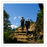
- Trekking in Bhutan -
Bhutan Mystic Bliss >> EASTERN BHUTAN
EASTERN BHUTAN
For further Details Contact Us
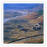 In Eastern Bhutan, there are few real valleys suitable for cultivation or habitation. Most of the valleys are simply made of riverbeds and the villages are perched high up along the slopes. This not a much traveled region of the country, however is very much known for its growing of rice, potatoes, lemon grass. It is also famous for its handloom textiles made from the famous weft loom method. A popular description of a trail in Eastern Bhutan is that it is up, up, up and down, down, down, up, up and up.... Eastern Bhutanese practiced shifting cultivation but nowadays, the government discourages this.
Lhuentse, one of the main places in the eastern Bhutan, is 77 kilometres from Mongar and is one of the most isolated districts in Bhutan. The landscape is spectacular with stark cliffs and gorges and dense coniferous forests. The region is notably famed for its weavers and special textiles and fabrics, generally considered to be the best in the country.
The Kurtoe region of Lhuentse is also the ancestral home of the Royal dynasty.
Mongar is divided into 16 gewogs:
» Balam
» Chaskar
» Chhali
» Dramtse
» Drepung
» Tsamang
» Gongdue
» Jurmey
 » Kengkhar
» Mangat
» Ngatshang
» Saleng
» Sherimung
» Silambi
» Thangrong
» Tsakaling
Lhuntse, previously Lhuntshi, is one of the 20 dzongkhag (districts) comprising Bhutan. It consists of 2506 households (Royal Government, Ninth Plan, pg. 2). Located in the northeast, Lhuntse is one of the least developed dzhongkhags of Bhutan. There are few roads, and the first gas station was opened as recently as September 2005. Electricity is not well distributed and the difficult terrain makes distribution of social welfare difficult. Despite its favourable climate, farming is also hindered by the difficult infrastructure.
Lhuntse is divided into eight gewogs (counties)
» Gangzur
» Jaray
» Khoma
» Kurtoe
» Menbi
» Metsho
» Minjay
» Tsenkhar
Trashiyangste is one of the 20 dzongkhag (districts) comprising Bhutan and is divided into eight gewogs (counties)
» Bumdeling
» Jamkhar
» Khamdung
» Ramjar
» Toetsho
» Tomzhangtshen
» Trashiyangtse
» Yalang
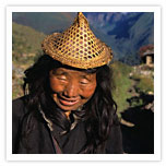
Trashigang, also spelled as Tashigang, is Bhutan's easternmost district. The inhabitants of Trashigang district are mainly Sharchops, which means "easterner" in Dzongkha, the national language. The Sharchops appear to mix Indian and Tibetan blood whereas the Ngalops of central and western Bhutan appear to be mainly Tibetan
While not a major urban area, Trashigang has the densest population in Bhutan. It used to be part of an important trade route connecting Assam to Tibet, and still is a primary route for Bhutanese trade with India. Major cities include Trashigang, Radhi, and Phongmey. The district produces a lot of rice and lavender. There are several tourist packages to Bhutan that include trips from Thimphu to Trashigang, despite the 17 hour journey from the capital over the rough and dangerous Lateral Road.
Trashigang dzongkhag is also the site of Sherubtse College, the only college within the Royal University of Bhutan system.
Trashigang Dzong, or fortress, was built in 1659 by the third Druk Desi to defend against Tibetan invaders. Because of its altitude, invading armies remarked "it is not a dzong on the ground, it is in the sky". It is simply one of the most memorable places in this district.
Trashigang is divided into 16 gewogs or counties:
» Bartsham
» Bidung
» Kanglung
» Khaling
» Lumang
» Merak
» Nanong
» Radhi
» Sakten
» Samkhar
» Shongphu
» Thrimsung
» UzorongYangneer of Wamrong
Western Region of Bhutan | Central Region of Bhutan | Eastern Region of Bhutan