Central Region of Bhutan


- Bhutan Visitor Info
- Western Region Bhutan -
- Central Region Bhutan -
- Eastern Region Bhutan -
- Festivals of Bhutan -
- National symbols -
- History of Bhutan -
- Culture of Bhutan -
- Religion of Bhutan -
- People of Bhutan -
- Bhutan Visa & Customs -
- Bhutan Accommodation -
- Bhutan Transportation -
- Climate of Bhutan -
- Currency of Bhutan -
- Paro Festival Bhutan -
- Trekking in Bhutan -
Bhutan Mystic Bliss >> CENTRAL BHUTAN
CENTRAL BHUTAN
For further Details Contact Us
On the east of Wangdue Phodrang, one comes across the Black Mountains with the Pelela pass (3400m). It is truly considered as a border between the western regions and the other regions of Bhutan, particularly the Central. Close to the Pelela and almost at the same altitude but still on the western side of the Black Mountains, on the southeast of Wangdi Phodrang, there are a few high altitudes valleys (3000m), of which Phobjika is the best known.
BUMTHANG is one of the 20 dzongkhag (districts) comprising Bhutan. It is the most historic dzongkhag if the number of ancient temples and sacred sites is counted. Bumthang consists of the four mountain valleys of Ura, Chumey, Tang and Choekhor (also known as Bumthang valley), although occasionally the entire district is referred to as Bumthang valley
Bumthang" literally translates as "beautiful field". "Thang" means field or flat place, and "Bum" is said be an abbreviation of either "bumpa" (a vessel for holy water, thus describing the shape and nature of the valley), or "bum" ("girl", indicating this is the valley of beautiful girls).
Some of the famous cultural and historical sites in the dzongkhag include:
Membar Tsho (Burning Lake), where sacred scriptures hidden by Guru Rimpoche in the 8th century were later recovered by Pema Lingpa in the 15th century.
Kurje Monastery and Jambay Lhakhang, the two most sacred and oldest temples in the whole of Bhutan. Jambay Lhakhang was built in the 7th century by Songtsen Gampo, the king of Tibet.
Tamshing Lhakhang, the most important Nyingmapa temple in the country.
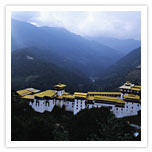
Jakar Dzong, named so since it is adjacent to the main town of Jakar. It is also the admistrative headquarters of Bumthang District and the place where Buddhism entered Bhutan.
The language spoken in the Bumthang district is known as Bumthangkha. It is a Tibeto-Burman language closely related to Dzongkha, the national language of Bhutan. Bumthangkha is partially comprehensible to speakers of Dzongkha, which originated in valleys to the west of Bumthang. Each of the four valleys of Bumthang has its own dialect, and the remnants of the Kheng kingdom to the south in Zhemgang speak Khengkha which may be classified as a dialect of Bumthangka. Winter wheat and buckwheat are staple diet, but the Bumthang farms also yield dairy products, honey, and apples among other products.
Bumthang is divided into four gewogs, which means a group of villages:
» Chhume
» Choekor
» Tang
Ura Bumthang is famous for its "yatra", colored woolen fabrics woven in the past on backstrap looms, but more recently on pedal looms.
Ura Valley or Ura Village is the last and the highest valley of Bumthang and to reach here, the road climbs through amazingly open countryside, occasionally running into forests. Large sheep pastures line the road and the route also crosses 3,600 m high Ura la pass, later descending into Ura by a long loop across fields and pastures. Perched at an altitude of 3,100 m, Ura village has characteristically close clustered houses, which are quite unusual in Bhutan. The day is for exploring fascinating Ura valley and village.
Moving east, one arrives in the valley of the Mangde River. It is the region of TRONGSA, which is of great importance in the history of Bhutan. Forested and dotted with good arable land, this region cannot be examined by itself but in relation with Bumthang. Trongsa, owing to its lower elevation than Bumthang (2200m instead of 2600m and above), was the winter ground and residence of the nobility of Bumthang, in the same way as Thimphu and Punakha were.
Trongsa is one of the districts of Bhutan. The center is at Trongsa Dzong bordered by Bumthang dzonghag on the east and by Wangdue Phodrang dzongkhag on the west. To the south it borders Tsirang, Sarpang, and Zhemgang dzongkhag.
Trongsa is divided into five gewog or counties
» Nubi
» Bjakteng
» Korphu
» Langthil
» Tangsibji
Today it is divided between the districts of Zhemgang and Mongar. This association was economic through grazing lands but also religious due to various lamas of Bumthang who were active in this region. The area to the east of Thrumsingla till Kurichu is not very populated. Forest and gorges compose the landscape, giving way to small, cultivated lands only 15 kms before the Kurichu River. The simplistic beauty of this part of Bhutan is exquisite.
Western Region of Bhutan | Central Region of Bhutan | Eastern Region of Bhutan